Cariad Instrumentation:
Summary:
A full battery of instruments is mounted at the cockpit steering stationSince the covers are on in the only view I have right now of the Cariad,
I’m going from memory in the diagram below:
Boat…..|….Wind…|…Depth…|
speed...|…speed/..|…………...|
………..|.direction..|…………...|
========================
Auto…|…GPS and radar……..|
Pilot…|…………………………|
As you can see from his grin,
there is enough information there to keep this helmsman very happy.
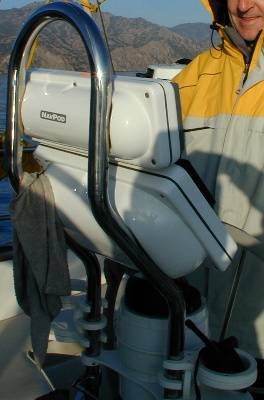
Radar features includes naming and tracking of up to 10 targets,
with the ability to display speed, course and the time and distance to Closest Point of Approach (CPA).
The GPS and radar may be displayed separately, superimposed or, as was the case for most of the Catalina trip, in split-screen format.
The nice thing about this split format is that it allows the strengths of each display format to be realized.
For example, the GPS map was good at showing the boat's location with respect to (wrt) static features
such as the coast, islands or buoys, while the radar image was good at showing the location of moving features like other boats.
This sounds potentially confusing, since the GPS display is "fixed" and shows a moving boat icon while the radar is "fixed" wrt the boat,
but it is very easy and intuitive in practice and gives a high degree of confidence in poor visibility.
Return to cover page
Check out some relevant
links.(Here is one to
Navpod.)